 The National Wilderness Preservation System (Wilderness Act)
After over 8 years of drafts, Howard Zahniser of the Wilderness Society wrote the version Congress finally passed as the Wilderness Act (text). Signed into law on September 3, 1964, the act created the National Wilderness Preservation System. Wallace Stegner’s beautiful and timeless “Wilderness Letter” introduced the act defining wilderness.
“A wilderness, in contrast with those areas where man and his own works dominate the landscape, is hereby recognized as an area where the earth and its community of life are untrammeled by man, where man himself is a visitor who does not remain.”
Initially the act designated 9 million acres of Forest Service lands. The Act required the Forest Service, National Park Service and Fish and Wildlife service to review all their lands for inclusion. In 1968 the first Fish and Wildlife lands, the Great Swamp of New Jersey, were designated. Later, in 1970, Craters of the Moon became the first designated National Monument land. The Petrified Forest became the first designated National Park.
Qualities of Wilderness Lands
Qualifying lands must be owned and managed by the federal government with at least five thousand acres. Lands must have a “substantially unnoticeable” human influence, contain opportunities for solitude and recreation, and possess “ecological, geological, or other features of scientific, educational, scenic, or historical value.”
Trail workers uses only hand tools and dynamite with no wheeled devices. Instead, horses typically transport supplies. While the President can authorize dams in wilderness areas, congress has to approve funds. The Wild and Scenic Rivers Act passed in 1968 in part to close this option.
Today, Forest Service, Fish and Wildlife (National Wildlife Refuges), BLM, and National Park Lands including National Monuments, are eligible for Wilderness designation. However, Wilderness Areas only began to include BLM land in 1976 with the passage of the Federal Land Policy and Management Act. The act stated that for the long term BLM lands could remain owned by the government. The government then assessed these lands in the late 1970’s and early 1980’s for wilderness designation. As a result so much BLM land became designated wilderness during that era.
There are also State and Tribal Wilderness Areas.
National Parks manage additional lands as wilderness even though they do not have designation by using their policy of “other categories of wilderness.” Between designated wilderness and the “other categories,” the National Park manages over 80% of its land as wilderness.
The Lands
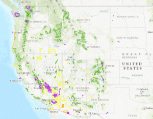
The act originally protected 9 million acres of Wilderness. Currently by far the most Wilderness Areas are in Alaska hence the thirteen largest are in the state. With 3.1 million acres, Death Valley possess the most wilderness in the lower 48 states (14th overall). The Magruder Corridor Road separates the next two largest in the lower 48, the Frank Church River of No Return Wilderness (2.3 million acres) and Selway Bitterroot (1.3 million acres). Many classic western rivers float through Wilderness Areas. Today 765 Wilderness Areas protect over 110 million acres with over 50% of the land being in Alaska, California is next with 14% and then Idaho, Arizona and Washington all have about 4%.
Who Manages Wilderness Areas
The National Park Service (established August 25, 1916) as part of the Department of the Interior manages most Wilderness Areas in National Parks as well as many National Monuments. Prior to this each state managed National Parks differently. Interestingly, the Department of Agriculture managed National Monuments until 1933 when Franklin Roosevelt signed two Executive Orders moving National Monuments, War Department Historic sites, and some D.C. parks under the management of the NPS.
NPS, FS, F&Wildlife, BLM, National Oceanic and Atmospheric Administration (manages marine national monuments) all manage National Monuments. Approximately 56% of wilderness acreage is managed by the National Park Service. The Forest Service manages 18%, US Fish and Wildlife 22% and BLM 4%.
History of National Monuments
National Monuments can contain non-federal land. National Monuments came from the Antiquities Act of 1906 which allowed the President to protect lands. That year President T. Roosevelt used the act to create Devil’s Postpile National Monument. In 1908, he made Grand Canyon National Monument, leading to a court battle. However, the US Supreme Court upheld the Monument in 1920. Further cases have maintained the President’s power to designate areas. Grand Canyon finally became a national park on February 26, 1919.
In 1996, President Clinton established Grand Staircase-Escalante as the first national monument administered by the BLM (part of the Department of the Interior). BLM Monuments and Wilderness areas are under the umbrella of the National Landscape Conservation System. Also known as the National Conservation Lands, it was created in 2000 and stayed in a precarious state until solidified with the passing of the National Landscape Conservation System Act in March 2009. The BLM is tasked with the responsibility to “conserve, protect, and restore these nationally significant landscapes that have outstanding cultural, ecological, and scientific values for the benefit of current and future generations.” Conservation Areas include National Monuments, National Conservation Areas, Wilderness Areas, Wilderness Study Areas, Wild and Scenic Rivers, National Scenic Trails, National Historic Trails, and Other Areas.
Notable Wilderness Areas
Grand Canyon-Parashant National Monument contains four wilderness areas: Grand Wash Cliffs, Paiute, Mt. Trumbull, and Mt. Logan Wilderness. Paria Canyon – Vermilion Cliffs, Kanab Creek, and Saddle Mountain Wilderness.
Frank Church River of No Return Wilderness Area: Middle Fork of the Salmon River, sections of the South Fork of the Salmon River and the Main Salmon River.
Selway-Bitterroot Wilderness Area: Selway River
Kalmiopsis Wilderness Area: Illinois River
Wild Rogue Wilderness: Rogue River